I took this geography class with Dr. Kinman during the spring semester sophomore year. I really enjoyed it, as I learned a lot about teaching geography to elementary school kids.
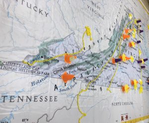
One of the materials that we used during an activity was a giant map of Virginia. The goal of this lesson was to show us the many ways that we can use it in our future classroom. For example, the first thing we did was place a card in our hometown. We then talked about the similarities and differences between places, pros and cons of each area, and the resources around our hometowns. While this would not be useful for elementary schoolers because they are all from the same area, I could alter the task and use locations of well known places, such as Kings Dominion, Virginia Beach, Jamestown, and the Blue Ridge Mountains. This would also be beneficial because I could connect the geography of these locations (ex: Jamestown) to what the students are learning in other subjects such as Virginia Studies.
Below, I have included a picture of what the giant map looked like with all of our cards marking our hometowns. This assignment has given me many ideas for future assignments that I can use with my elementary schoolers. I am looking forward to utilizing this resource in my future classroom.