13
October
October
Data Analysis – Local Precipitation
Comments Off on Data Analysis – Local Precipitation Posted in: Uncategorized
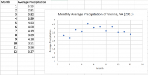
This data set is the monthly average of rain from 2010 in Vienna, VA.

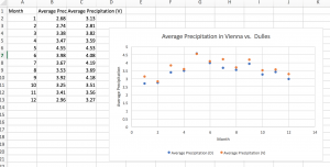
This second set is from the monthly average at Washington Dulles International Airport also in Virginia. Part of my interest in this data set is that I live right near both of these places. While Vienna and Dulles Airport are only 13 miles apart, there are some slight differences in the average monthly precipitation. However, they are both relatively similar in their monthly averages which makes sense considering their proximity. These charts do not account for snowfall in these areas.

This third chart just has the two areas monthly averages for a side by side comparison. Both of these areas experienced their highest monthly average of 2010 in May. This side-by-side scatterplot makes it easier to visually compare the two sets of data. All data was found here.
Recent Comments